
Haute Route San Francisco Stage 3 moves to Angel Island
The Haute Route San Francisco Stage three route will be more epic than expected, as they couldn't pass up the chance to shut down Angel Island where Haute Route will be the first road cycling event ever permitted on the island!
Even the locals tell us this isn't something they have experienced before! Angel island is a hidden gem in San Francisco Bay, offers expansive 360 degree views of the San Francisco skyline, the Marin County headlands and Mount Tamalpais. On a clear day, Sonoma and Napa can be seen from the north side of the island. The time trial itself will consist of two laps of the 4.9-mile perimeter road around the island.
The San Francisco Bay Area is one of the jewels of American cycling, with world-class climbs, quiet roads, and unbeatable vistas only short distances from the hearts of San Francisco and Oakland
Some of the world’s best cyclists call this area home and use climbs like Mt. Diablo and Mt. Tam for training. They race over these same roads, too. The three Haute Route San Francisco routes cover parts of eight different Amgen Tour of California stages!

The Haute Route San Francisco offers cyclists a whole new way to enjoy these iconic routes and satisfy your desire for competition. In a competitive road race, every inch of the course counts toward your finishing time, and the only way to win is to reach the finish line first. What makes Haute Route San Francisco different is that only the timed sections of the course count toward the competition! So, rather than racing all the way from start to finish or being knocked out of contention by a flat tire along the way, you can ride with friends of varying ability levels, stop to admire the stunning views, take your time enjoying the fully-stocked aid stations, and then go as hard as you can – either solo or in a group – to record the segment times that will determine your ranking for the stage and overall.
The exact number of timed segments will vary from stage to stage, as will their lengths and characteristics. Overall, you should expect timed segments to make up less than half of both Stages 1 and 2. Some timed segments will be climbs, but this is more than just a climbers’ race, so there will be timed segments through flat areas and rolling hills that will favor rouleurs and reward groups that work well together.
April is a great time to ride in Marin County as well as inland from Oakland. Daytime highs are likely to be in the 60s, but the weather in the Bay Area changes quickly. The insider advice from locals is to bring plenty of layers. You’ll likely want to start with a vest and arm warmers or a light jacket, and maybe knee warmers, but you will also want the ability to unzip or shed layers as conditions change. Keep them with you, though. Both Stages 1 and 2 feature long descents that can get chilly, even on warm days.


Stage 1: Oakland – Mt. Diablo – Oakland
100 miles | 11,000 feet of elevation gain
After a neutral 5-mile spin from Jack London Square through Berkeley, the road kicks up for a roughly 2-mile climb up Claremont Avenue. The next 19 miles roll up and down through Redwood Regional Park and past the Upper San Leandro Reservoir, until you drop down to the first Aid Station in the outskirts of Hayward, CA.
It is important to start Mt. Diablo with plenty of fluids. You should expect the climb to the summit Aid Station to take at least an hour. Three stages of the Amgen Tour of California have featured Mt. Diablo, and top male pro times for the south side of Mt. Diablo are about 40-45 minutes, with top female pro times at about 50-55 minutes.
The timed section of Mt. Diablo is 10 miles, encompassing about 3400 feet of elevation gain. The first seven miles meander at reasonable grades below 7%. The final three are tougher, as grades increase to 8-10%. Keep something in reserve for the final pitch, which ramps up to 15%. If you crack here you can lose a minute or more!
After enjoying the views atop Mt. Diablo, it’s time to descend. When you reach the intersection with North and South Gate Roads, turn right on to North Gate Road. The northern descent of Mt Diablo drops 3500 feet in 11 miles, and can be quite chilling, so carry appropriate clothing. Keep in mind; the descent is not timed. There are no extra points for descending like a daredevil. Have fun, but be safe.
After passing through Mt. Diablo’s North Gate you’ll ride about 30 miles of rolling terrain through Walnut Creek before starting Stage 1’s final timed segment, the 5.7-mile Grizzly Peak climb. One hint about this climb; the tricky part is the flat section in the middle!
All timing for the stage ends at the summit and you have an 8-mile downhill cruise to the finish in Jack London Square. You must cross the finish line in Jack London Square to officially finish and have your timed segments counted toward stage and overall rankings.
![]() Haute Route San Francisco Stage 1
Haute Route San Francisco Stage 1
Stage 2 – Presidio – Marin County – Presidio
Approx. 90 miles | 8500 feet of elevation gain
Stage 2 is a classic and unforgettable North Bay route featuring the Golden Gate Bridge, ocean views, and a ride through the Redwoods. The stage starts in the Presidio and rolls across the Golden Gate Bridge with exclusive access to the west-side pedestrian path. After riding through Sausalito, you’ll head up Shoreline Highway and then turn right on to Panoramic Highway to climb part of the south side of Mt. Tam (including a 4.5-mile timed segment).
Starting at about 16.5 miles into the stage, enjoy the untimed 4-mile descent down Panoramic Highway to Route 1 in Stinson Beach and head north along Bolinas Lagoon to Olema, before turning onto Sir Francis Drake Boulevard. After a short climb and descent, the next 11 miles is a gradual false-flat climb that ascends about 500 feet before dropping into Fairfax.
.png "You’ll ride over the iconic Golden Gate Bridge twice, this is a ride you'll never forget")
Leaving Fairfax, you’ll encounter a roughly 3.5-mile climb up Pine Mtn. Pass, followed by a 4-mile winding descent to Alpine Dam. The next climb starts about one-third of a mile past the Alpine Dam. This beautiful climb through a Redwood forest rises 820 feet in 2 miles at an average 8% grade. There will be a timed segment starting outside Fairfax and ending at the top of the Alpine Climb.
From the top of Alpine get ready for a twisting and scenic descent down to Route 1, only this time you’ll turn left and head toward Stinson Beach before heading up a roughly 4-mile climb on Panoramic Highway. From the summit of this climb it’s about an 8.5-mile descent (with a few rollers) to the base of Shoreline Highway.
After spinning your way through Sausalito, you have one final 2.9-mile timed climb up Hawk Hill, which rises 700 feet onto the Marin Headlands. After climbing Hawk Hill you will again cross the Golden Gate Bridge and return to the Presidio. You must cross the finish line in the Presidio for your segments to count toward stage and overall rankings.
Local pro cyclist and Haute Route Ambassador, Alison Tetrick, advises that the key to having a great day on this route is having the right clothing. “I ride parts of this course at least twice a week, and the one constant is that the weather is unpredictable.” In the span of a few hours you can experience bright sun, dense fog, short-sleeve temperatures, rain showers, and jacket weather. “A lightweight rain jacket is perfect because it’s versatile. It’s great for staying warm on some of the longer descents when you’re sweaty from climbing, it’s a wind-proof layer if the temperature drops, and of course it’s great for staying dry if it starts to rain. I also carry a pair of medium-weight full-finger gloves. You don’t want to get cold on this route because if you do, you’re likely to stay cold.”
![]() Haute Route San Francisco Stage 2
Haute Route San Francisco Stage 2
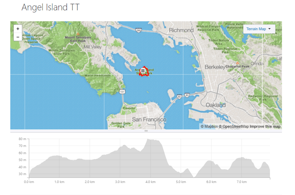
Stage 3 – Angel Island Time Trial
9.8 Miles | 850 feet of elevation gain
Stage 3 will be a unique treat, even for locals, because Haute Route San Francisco has secured all of Angel Island just for our event! Riders will take a chartered ferry to Angel Island in the morning, arriving before the island is open for tourists. You will have the opportunity to ride a warm up lap of the course, not only to stretch your legs but also to take in the incredible views. The time trial itself will consist of two laps of the 4.9-mile perimeter road around the island. There are no major climbs on the course, but the rolling terrain and short, punchy hills adds up to 425 feet of climbing per lap.
At the conclusion of the time trial, enjoy a closing brunch on island, where we will also hold the Closing Ceremony to crown the first ever Haute Route San Francisco champions! All riders will be transported back to Pier 43½ by chartered ferry, or you can choose to take a public ferry if you’d like to leave earlier or later than the Haute Route ferry.
![]() Haute Route San Francisco Stage 3
Haute Route San Francisco Stage 3

 Prologue ITT


