Haute Route Announces 2018 Route for Mavic Haute Route Rockies
7-Day International Event Features Over 50,000 Feet of Climbing Including 14,000-Foot Ascent of Pikes Peak – America’s Mountain
COLORADO SPRINGS, Colo. (March 12, 2018) – Haute Route, the world’s most prestigious multi-day event series for amateur cyclists, today announced the route for the second edition of the Mavic Haute Route Rockies. Kicking off in the official start city of Boulder, Colo. on June 23, 2018, the seven-day event spans 527.8 miles with over 50,000 feet of climbing before ending in Colorado Springs, Olympic City USA.
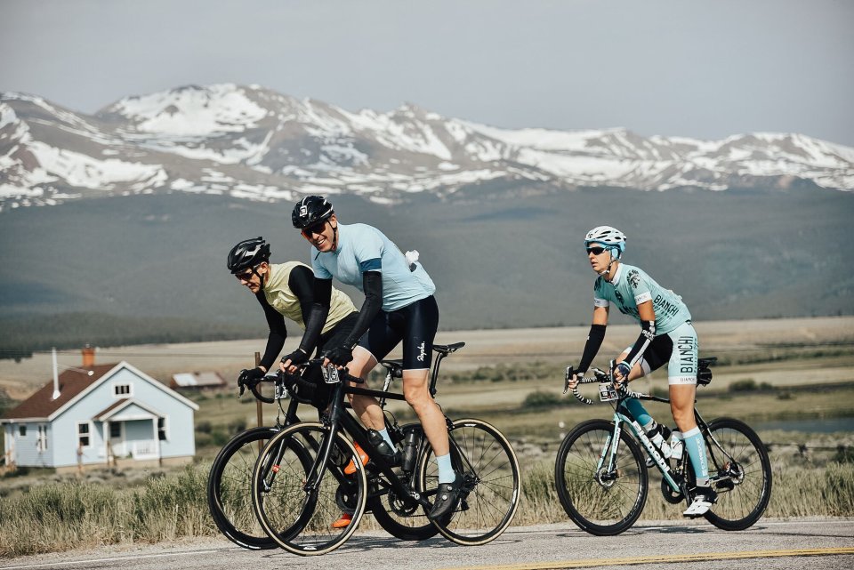
The Mavic Haute Route Rockies 2018 course includes an epic climb over 14,000 feet to the summit of Pikes Peak-America’s Mountain, one of the most famous summits in the United States and one of only two paved roads above 14,000 feet in the United States, during the final stage. Leaving from Woodland Park, the riders will use a private road not normally accessible to cyclists on the north slope of the mountain and will connect to the Pikes Peak Highway with 12 miles to go to the finish—the same place where the famous Pikes Peak Hill Climb starts.
“The second edition of Mavic Haute Route Rockies promises to be unforgettable, with breathtaking scenery and iconic climbs. As promised, we have eliminated all gravel sections and have kept only a few hard-packed dirt sections easily ridden on a road bike. These sections will showcase some of Colorado’s most memorable landmarks, enhancing the riders’ experience,” said Micah Rice, Head of Operations for Haute Route North America. “We planned the route to make it easier for riders to recover after long days on the bike with two nights each in Boulder, Avon and Breckenridge.”
“Building on the success of last year’s inaugural U.S. event, our Haute Route team has carefully planned the second edition of the Mavic Haute Route Rockies. The 2018 event truly has all the hallmarks of Haute Route including, challenging terrain, long iconic climbs, beautiful scenery and unparalleled pro-like support both on and off the bike,” said Haute Route North America Chairman Alain Lambert. “As an amateur cyclist myself who has ridden multiple seven-day Haute Route events, including the first edition of the Mavic Haute Route Rockies, I can state the 2018 edition will test cyclists of all levels and take their breath away with the quality of the parcours designed by our team. Chapeau!”
VIDEO: Mavic Haute Route Rockies Preview with Dave Towle
 Stage 1: Boulder to Boulder
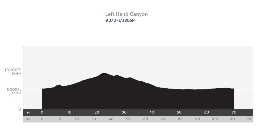
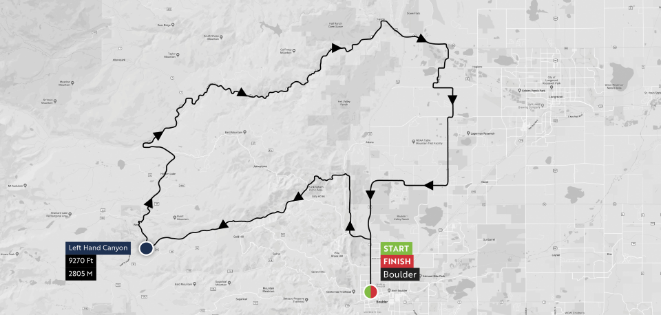
Saturday, June 23, Distance: 69 miles | 6795 feet of climbing | 6795 feet of descending!
From the start on the famous Pearl Street Mall in Boulder, riders will head north out of town on the to Lefthand Canyon. This 14-mile ascent to the town of Ward gains more than 3000 feet and takes you up to the day’s high point at 9300 feet above sea level. It’s one of the most popular climbs for locals and pros, especially in the summer, because it offers shady trees and cooling stream along the side of the road. From Ward you’ll gradually descend over a few rolling hills on the iconic Peak-to-Peak Highway, before descending the rest of the way down to Lyons via St. Vrain Drive.
The final 23 miles of Stage 1 are reasonably flat and can be windy, so it will be advantageous to leave the town of Lyons in a group to share the work. Save a little fuel in the tank, however, for a gradual rise that tops out only a few miles from the finish in downtown Boulder.
 Stage 2: Boulder to Winter Park
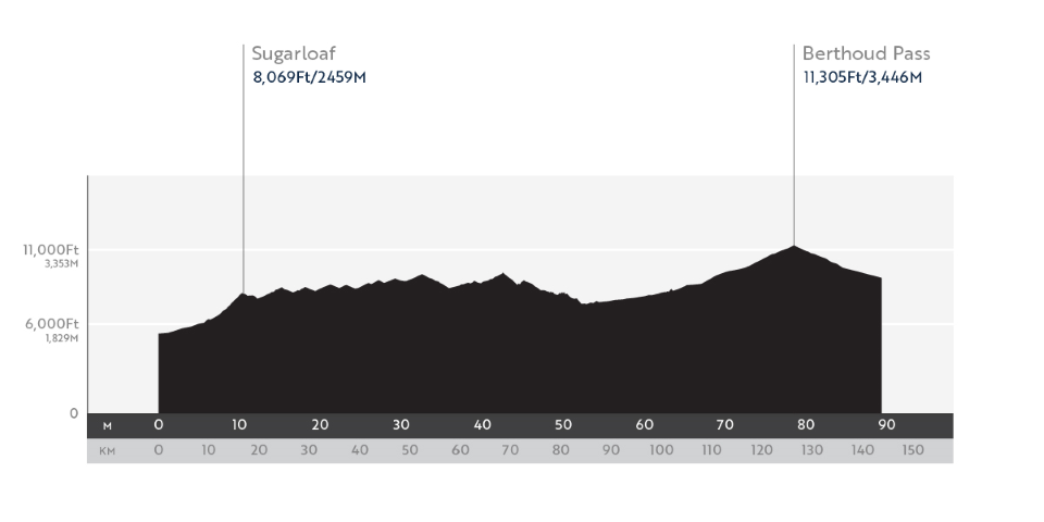
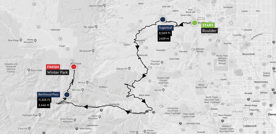
Sunday, June 24, Distance: 87.5 miles | 12,060 feet of climbing | 8290 feet of descending!
With Stage 1 as an appetizer, Stage 2 of the Mavic Haute Route Rockies features double the climbing over the course of nearly 90 miles. If you’re feeling the least bit stiff in the morning, get in a quick spin before the start because the climb up Boulder Canyon begins only minutes into the stage. After a few miles on Boulder Canyon Road you’ll turn onto Sugarloaf Drive, which will climb up and intersect with the Peak-to-Peak Highway 16 miles into the day.
The next 30 miles from Nederland all the way through the outskirts of Central City includes some rolling hills and few sharp inclines, but you’ll generally be riding at elevations between 8,000-9,00 feet. The big thing to remember here is that charging up short climbs at this elevation can sap energy you’ll need later in the day. After Central City, enjoy the descent down to Idaho Springs.
The ride from Idaho Springs to Empire is a gradual 1200-foot climb over about 11 miles as you parallel Interstate 70. The town of Empire, 65 miles into the stage, marks the beginning of Berthoud Pass, the last and biggest challenge of the day. This 13-mile climb ascends 2680 feet and tops out at 11,297 feet above sea level. You will definitely feel the effects of altitude on this climb, but you’ll also love the wide road and sweeping switchbacks!
The descent off the north side of Berthoud Pass is fast and fun, but beware of the long straightaways between Mile 82 and Mile 85. There are two long straightaways here where you can gain a lot of speed, but both end in tight switchbacks. Have fun, but control your speed! The last few miles are gentle downhill roll to the finish at the Winter Park Resort.
 Stage 3: Winter Park to Avon
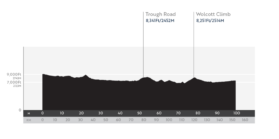
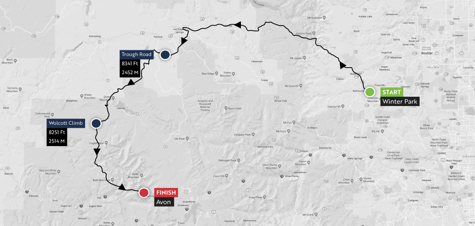
Monday, June 25, Distance: 94.2 miles | 6987 feet of climbing | 8631 feet of descending!
Stage 3 starts out with a nice, gentle rollout before its first big challenge about 16 miles in. About 13 miles into the stage, keep your eyes out for a sign on the left side of the road for Snow Mountain Ranch. Immediately after that sign you will begin a fast descent, and at about Mile 16 you’ll take a left turn onto a hardpack dirt road. From the turn to the summit of Cottonwood Pass is 5.3 miles. While this climb may be a great place to split the peloton into groups, you better like descending on gravel if you want to stay in the front. The roughly 4-mile descent to Hot Sulphur Springs isn’t technical or that rough, but it can be tricky nonetheless.
If the wind is coming from the east, the next segment of the course will be fast and fun. Westerly winds will mean the exact opposite, because the road from Hot Sulphur Springs to Kremmling is wide and wide open as you roll through flowing grasslands. What follows is a series of three 2- to 3-mile climbs as you make your way to State Bridge. Use the descent from Mile 62 to Mile 65 miles to fuel and hydrate. Your next challenge awaits on the other side of the Colorado River.
State Bridge is a beautiful crossing of the Colorado River, and it also marks the start of a 5-mile climb on the way to Wolcott. When this climb was used in the 2013 USA Pro Challenge, when Lawson Craddock claimed the Strava KOM with a time of 19:52.
After descending into Wolcott, you’ll face a pretty but challenging false flat as you gradually climb to the finish in Avon. For those of you who are into sprinting for the finish line, this will be a relatively technical finish. With less than a mile to go, you will ride left through a roundabout, cross the Eagle River, take the next left, and then sweep through a right turn and over railroad tracks to line up for the final few hundred meters!
 Stage 4: Avon Time Trial
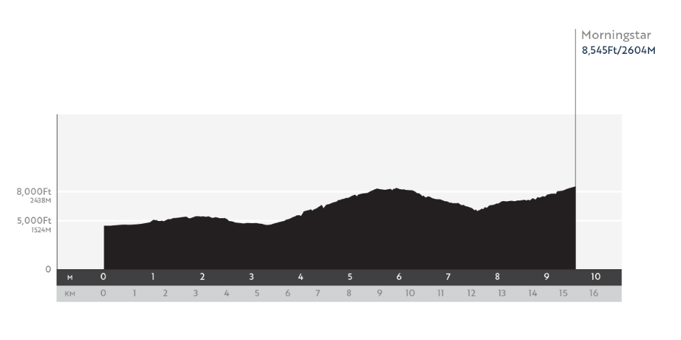
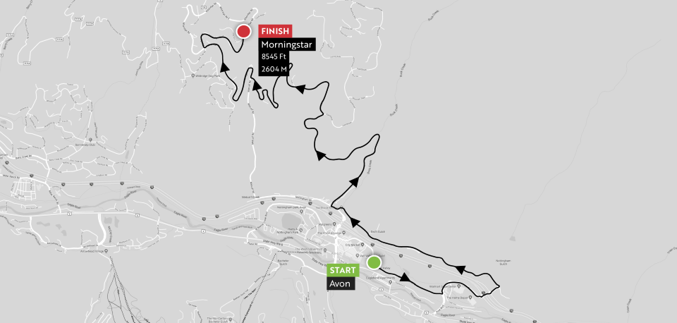
Tuesday, June 26, Distance: 9.6 miles | 2060 feet of climbing | 974 feet of descending!
The Stage 4 individual time trial will reward both climbing and descending skills, as you’ll climb 2060 feet and descend more than 900 over the course of 9.6 miles. After negotiating 5 roundabouts in the first 1.5 miles, you’ll reach the foot of the first climb 3.3 miles into the stage. This will be a roughly 2.2-mile climb at an average grade of nearly 8% and 950 feet of elevation gain. The suffering will be worth it, however, because the ripping descent which follows will test your handling skills with 4 switchbacks! Catch your breath on the descent before immediately starting up a roughly 2-mile climb, at an average grade of about 6%, to the summit finish.
 Stage 5: Avon to Breckenridge
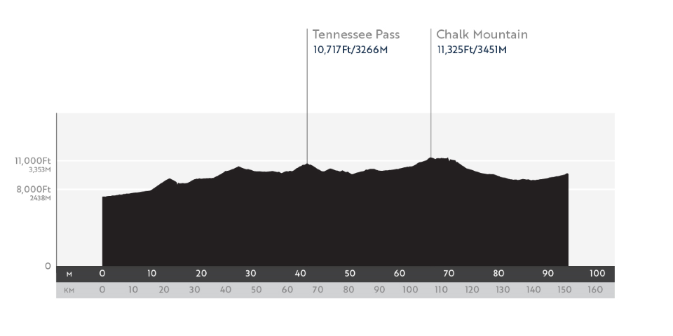
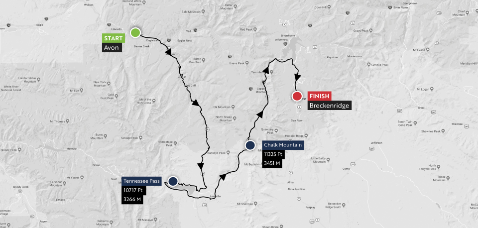
Wednesday, June 27, Distance: 92.7 miles | 8746 feet of climbing | 6487 feet of descending!
Stage 5 features three prominent climbs: Battle Mountain, Tennessee Pass, and Fremont Pass. Although Battle Mountain and Tennessee Pass are two separate climbs, it might be better to consider the first 27 miles of Stage 5 as one big climb with a short reprieve after about 13 miles. Keep an eye out for the iconic Red Cliff Bridge over the Eagle River.
After reaching the top of Tennessee Pass (10,400 feet) you can try to recover over the next 9 miles or so before starting a scenic and challenging loop around Turquoise Lake, which will bring you back to Leadville, Colorado. At 10,200 feet above sea level, Leadville is the highest city in the United States, even more so since recreational marijuana use was legalized in Colorado! Leadville is a historic boom-and-bust mining town, and after the last mining bust local Ken Chlouber started the Leadville Race Series. The iconic 100-mile Leadville 100 Mountain Bike Race and Leadville 100 Run finish on 6th Street, the same road you’ll be using to ride into town.
After riding through the heart of Leadville you’ll tackle the climb to the Climax Mine and the high point of the stage: Fremont Pass at 11,340 feet above sea level. From there the first few miles of the descent to Frisco are gentle, and include a ride across the dam at the Clinton Gulch Dam Reservoir, before a more significant drop past Copper Mountain. From Frisco it’s a very gradual climb up to the stage finish in Breckenridge.
 Stage 6: Breckenridge to Breckenridge
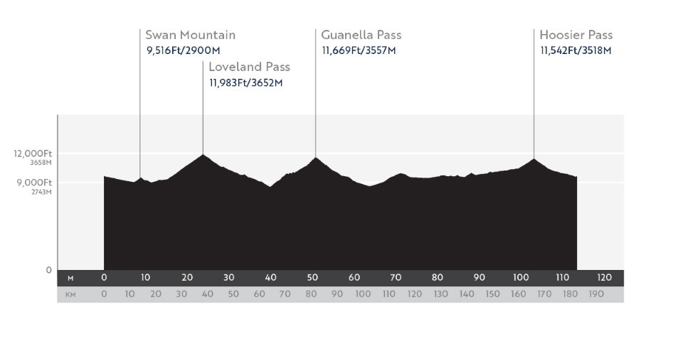
Thursday, June 28, Distance: 111 miles | 11,352 feet of climbing | 11,352 feet of descending!
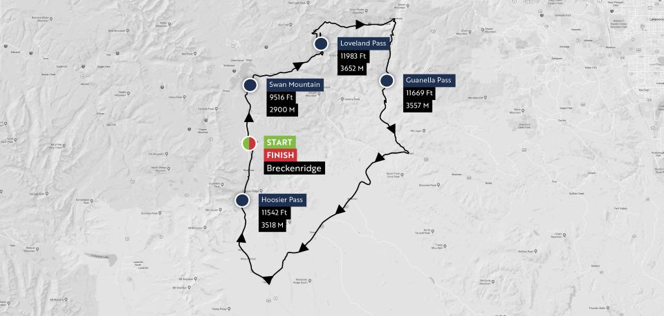
The “Queen Stage” for the Mavic Haute Route Rockies features three huge climbs, two that top out above 11,000 feet and one that hits nearly 12,000 feet above sea level. This 111-mile loop from Breckenridge, CO is going to be a great day, and a big challenge! Be sure to pack a jacket and long finger gloves; the long high-altitude descents can get chilly.
The stage starts with a gradual downhill roll out of Breckenridge, followed by the short climb up Swan Mountain to wake up your legs. At Mile 15 you’ll pass Keystone Ski Resort and start the 8.7-mile climb to the 11,991-foot summit Loveland Pass. The grade on the climb is pretty tame at 6%, but the altitude will add to the challenge.
After summiting Loveland Pass, enjoy the 16-mile descent down to Georgetown, CO. Make sure you eat and hydrate during this section, because the 11-mile climb of Guanella Pass starts as soon as you leave town! Guanella is a spectacular, scenic, and recently paved climb that ascends 3050 feet to the summit at 11,671 feet. It’s also a very challenging climb, with steep grades for the first 4 miles, a respite in the middle as you pass two big reservoirs, and then steep grades again in the last 5.5 miles. What goes up must come down, so enjoy your reward of a 13-mile descent that drops more than 3,000 feet!
The roughly 28 miles between Grant and Fairplay will be a good place to ride with a group, as this area can get windy. The climb over Kenosha Pass will seem like a minor bump compared to the stage’s bigger climbs, and it’s followed by rolling hills on the way to Fairplay.
The summit of Hoosier Pass is 12 miles from Fairplay, and the first 8 miles roll up and down as you gradually ascend and pass through the town of Alma. About a mile past Alma you’ll get to the true Hoosier Pass climb, which ascends 1000 feet over 3.7 miles to the 11,500 foot summit. From here, the first three miles of the descent are fast and somewhat technical, and then the final 7 miles of the stage are a rolling descent down to the finish in Breckenridge!
 Stage 7: Woodland Park to Colorado Springs
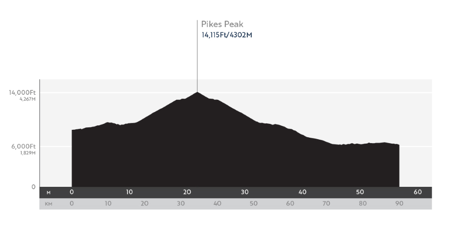
Friday, June 29, Distance: 54.3 miles | 7370 feet of climbing | 9609 feet of descending!
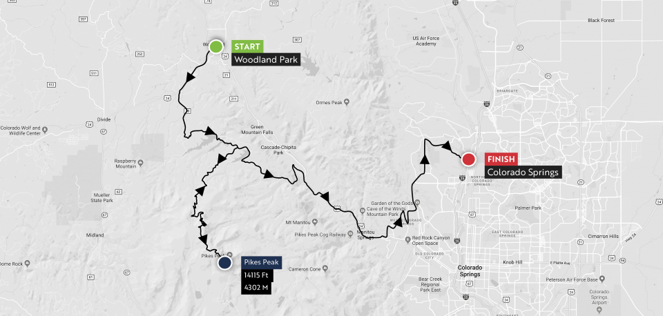
For Stage 7, the Mavic Haute Route Rockies is going where even the USA Pro Challenge wouldn’t: the 14,100-foot summit of Pikes Peak! Though the Pikes Peak Highway is open to cyclists year round, this route, which begins at 8,500 feet above sea level in Woodland Park, has never before been featured in any amateur or professional cycling event.
Traditionally, cyclists and motorists access the Pikes Peak Highway through the main gate at the base of the mountain, and then climb up the road to the start line for the Pikes Peak International Hill Climb, which will also be the start of a 12.4-mile timed segment. For the first time ever, Haute Route has secured access to this starting line by way of a little-known road through private land. Along the way there will be 3.6 miles on well-maintained dirt roads and riders will pass two incredible mountain lakes while enjoying views of Pikes Peak few others get to see.
Once on Pikes Peak Highway, riders will face a 12.4-mile paved ascent that gains 4720 vertical feet. Retired pro cyclist, Phil Gaimon, set the record on this climb at 1:08:46 during the 2017 USA Cycling Hill Climb National Championship, whereas fit amateur cyclists should expect the climb to take 1:30:00 to 1:45:00.
The views from the Pikes Peak Highway and atop Pikes Peak are breathtaking, and riders who achieve the summit earn the reward of a thrilling 26-mile descent that drops 7900 feet to Garden of the Gods and one final sharp half-mile climb before the stage finish and party!
Staying true to the hallmarks of every Haute Route, Mavic Haute Route Rockies provides amateur riders with the authentic pro experience on and off the bike. Athletes will experience the best roads in Colorado and are fully supported with premium services typically reserved for the pro peloton.
Accommodations packages are available for all Mavic Haute Route Rockies participants, including hotel selections located as close as possible to the start and finish area as well as early breakfast and daily transportation of travel bags. For each level of accommodations riders can choose from three different room options, including individual (single room), couple (double room) or individual to share a room with another rider (twin room). Friends and family of Haute Route riders also have the opportunity to purchase any one of the accommodation packages. Click here for more details and prices on these packages.
To register for the 2018 Mavic Haute Route Rockies, go to https://www.hauteroute.org/events/how-to-enter/mavic-rockies-2018.
About Haute Route
Haute Route was created in 2010 by global sports marketing and event company OC Sport to deliver an unparalleled professional experience both on and off the bike for amateur riders. Taking place in the world’s most iconic cycling destinations, the events are timed, ranked and fully supported with premium services typically reserved for the pro’s. Haute Route launched its first North American event in June of 2017 with the Mavic Haute Route Rockies. For more information and to access the full 2018 Haute Route calendar of events, which includes three new three-day U.S. events, Haute Route San Francisco (April 20-22), Haute Route Asheville (May 18-20) and Haute Route Utah (September 14-16), as well as the second edition of the Mavic Haute Route Rockies (June 23-29), please visit www.hauteroute.org.

